![](/images/other/stat-length.png)
![Trail Walking Gemeinde Neustift im Stubaital - Elfer, Kar- und Pinnisalm - Photo](https://media.geolcdn.com/t/1900/400/ext.pjpeg?maxdim=2&url=https%3A%2F%2Fstatic1.geolcdn.com%2Fsiteimages%2Fupload%2Ffiles%2F1553511878bg_sport_marche.png)
Elfer, Kar- und Pinnisalm
ErwinMueller
User
![Length](/images/other/stat-length.png)
Length
7.6 km
![Max alt](https://static1.geolcdn.com/siteimages/upload/files/1508320355ic_sort_altitude_max_24dp.png)
Max alt
2166 m
![Uphill gradient](https://static1.geolcdn.com/siteimages/upload/files/1508320355ic_sort_den_pos_24dp.png)
Uphill gradient
386 m
![Km-Effort](/images/other/stat-length.png)
Km-Effort
13.6 km
![Min alt](https://static1.geolcdn.com/siteimages/upload/files/1508320355ic_sort_altitude_min_24dp.png)
Min alt
1554 m
![Downhill gradient](https://static1.geolcdn.com/siteimages/upload/files/1508320355ic_sort_den_neg_24dp.png)
Downhill gradient
628 m
![Boucle](https://static1.geolcdn.com/siteimages/upload/files/16400158638029165_repeat_loop_refresh_sync_direction_icon.png)
Boucle
No
Creation date :
2019-01-16 09:36:15.538
Updated on :
2019-01-16 09:36:15.538
![Walking](https://static1.geolcdn.com/sitytour/trail-icons/101.png)
2h36
Difficulty : Medium
![Scan this QR Code to open this trail in the SityTrail application](https://capi.geolives.com/qq0zvz2zws4bq2lad0pu/sitytour/trails/1011171/qr.png?size=200)
FREE GPS app for hiking
About
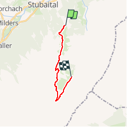
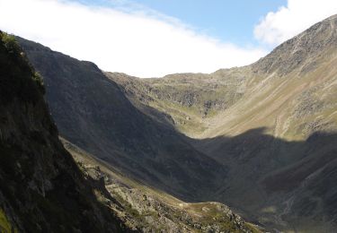
Trail Walking of 7.6 km to be discovered at Tyrol, Bezirk Innsbruck-Land, Gemeinde Neustift im Stubaital. This trail is proposed by ErwinMueller.
Description
Vom Elfer zur Elferhütte, dann den Panoramaweg entlang runter zur Karalm, dann zur Pinnisalm und mit dem Hüttentaxi zurück zum Elferlift
Positioning
Country:
Austria
Region :
Tyrol
Department/Province :
Bezirk Innsbruck-Land
Municipality :
Gemeinde Neustift im Stubaital
Location:
Unknown
Start:(Dec)
Start:(UTM)
676305 ; 5218726 (32T) N.
Comments
Trails nearby
![Trail On foot Gemeinde Neustift im Stubaital - Wilde Wasser Weg - Photo](https://media.geolcdn.com/t/375/260/70f39b52-5b6f-4aeb-9e90-b5bb5a6b221b.jpeg&format=jpg&maxdim=2)
![On foot On foot](https://static1.geolcdn.com/sitytour/trail-icons/100.png)
Wilde Wasser Weg
On foot
Easy
Gemeinde Neustift im Stubaital,
Tyrol,
Bezirk Innsbruck-Land,
Austria
![](/images/other/stat-length.png)
3.5 km | 8.9 km-effort
2h 0min
![](https://static1.geolcdn.com/siteimages/upload/files/16400158638029165_repeat_loop_refresh_sync_direction_icon.png)
No
![Trail On foot Gemeinde Rinn - Hasental-Trail - Photo](https://media.geolcdn.com/t/375/260/2ef403ba-f96e-4e77-a8e7-6adba28f9e16.jpeg&format=jpg&maxdim=2)
![On foot On foot](https://static1.geolcdn.com/sitytour/trail-icons/100.png)
Hasental-Trail
On foot
Easy
Gemeinde Rinn,
Tyrol,
Bezirk Innsbruck-Land,
Austria
![](/images/other/stat-length.png)
8.1 km | 11.2 km-effort
2h 32min
![](https://static1.geolcdn.com/siteimages/upload/files/16400158638029165_repeat_loop_refresh_sync_direction_icon.png)
Yes
![Trail On foot Unknown - Stangensteig-Trail - Photo](https://media.geolcdn.com/t/375/260/e4cfbff7-ae14-4240-acdb-812b0d0ca510.jpeg&format=jpg&maxdim=2)
![On foot On foot](https://static1.geolcdn.com/sitytour/trail-icons/100.png)
Stangensteig-Trail
On foot
Easy
Unknown,
Tyrol,
Innsbruck,
Austria
![](/images/other/stat-length.png)
8.9 km | 12.8 km-effort
2h 54min
![](https://static1.geolcdn.com/siteimages/upload/files/16400158638029165_repeat_loop_refresh_sync_direction_icon.png)
Yes
![Trail On foot Unknown - Rauschbrunnen-Runde - Photo](https://media.geolcdn.com/t/375/260/5c4143ba-b719-4790-b6e2-9ba50f884458.jpeg&format=jpg&maxdim=2)
![On foot On foot](https://static1.geolcdn.com/sitytour/trail-icons/100.png)
Rauschbrunnen-Runde
On foot
Easy
Unknown,
Tyrol,
Innsbruck,
Austria
![](/images/other/stat-length.png)
7.9 km | 13.7 km-effort
3h 6min
![](https://static1.geolcdn.com/siteimages/upload/files/16400158638029165_repeat_loop_refresh_sync_direction_icon.png)
Yes
![Trail On foot Pfitsch - Val di Vizze - 2 - Photo](https://media.geolcdn.com/t/375/260/0b3dba47-bf45-4a99-83cc-5eeecec76284.jpeg&format=jpg&maxdim=2)
![On foot On foot](https://static1.geolcdn.com/sitytour/trail-icons/100.png)
2
On foot
Medium
Pfitsch - Val di Vizze,
Trentino-Alto Adige/Südtirol,
South Tyrol,
Italy
![](/images/other/stat-length.png)
6.9 km | 22 km-effort
5h 3min
![](https://static1.geolcdn.com/siteimages/upload/files/16400158638029165_repeat_loop_refresh_sync_direction_icon.png)
No
![Trail On foot Ratschings - Racines - IT-30 - Photo](https://media.geolcdn.com/t/375/260/473ce5f4-9419-4d08-9ab8-783ba4dbff8b.jpeg&format=jpg&maxdim=2)
![On foot On foot](https://static1.geolcdn.com/sitytour/trail-icons/100.png)
IT-30
On foot
Difficult
Ratschings - Racines,
Trentino-Alto Adige/Südtirol,
South Tyrol,
Italy
![](/images/other/stat-length.png)
17.8 km | 34 km-effort
7h 47min
![](https://static1.geolcdn.com/siteimages/upload/files/16400158638029165_repeat_loop_refresh_sync_direction_icon.png)
No
![Trail On foot Moos in Passeier - Moso in Passiria - IT-29 - Photo](https://media.geolcdn.com/t/375/260/71093c18-e8ef-4bdf-b1e2-323abd6a7036.jpeg&format=jpg&maxdim=2)
![On foot On foot](https://static1.geolcdn.com/sitytour/trail-icons/100.png)
IT-29
On foot
Easy
Moos in Passeier - Moso in Passiria,
Trentino-Alto Adige/Südtirol,
South Tyrol,
Italy
![](/images/other/stat-length.png)
11.9 km | 18.2 km-effort
4h 8min
![](https://static1.geolcdn.com/siteimages/upload/files/16400158638029165_repeat_loop_refresh_sync_direction_icon.png)
No
![Trail On foot Ratschings - Racines - IT-28 - Photo](https://media.geolcdn.com/t/375/260/2169872e-5620-4e34-bc39-6d261bc853f8.jpeg&format=jpg&maxdim=2)
![On foot On foot](https://static1.geolcdn.com/sitytour/trail-icons/100.png)
IT-28
On foot
Medium
Ratschings - Racines,
Trentino-Alto Adige/Südtirol,
South Tyrol,
Italy
![](/images/other/stat-length.png)
11 km | 25 km-effort
5h 35min
![](https://static1.geolcdn.com/siteimages/upload/files/16400158638029165_repeat_loop_refresh_sync_direction_icon.png)
No
![Trail On foot Brenner - Brennero - IT-1 - Photo](https://media.geolcdn.com/t/375/260/b8bf571a-08af-4de3-88b8-6ba0b1884ea7.jpeg&format=jpg&maxdim=2)
![On foot On foot](https://static1.geolcdn.com/sitytour/trail-icons/100.png)
IT-1
On foot
Difficult
Brenner - Brennero,
Trentino-Alto Adige/Südtirol,
South Tyrol,
Italy
![](/images/other/stat-length.png)
19.1 km | 33 km-effort
7h 23min
![](https://static1.geolcdn.com/siteimages/upload/files/16400158638029165_repeat_loop_refresh_sync_direction_icon.png)
No